I'd guess osrmIsochrone has changed since, another indicator is the use of deprecated returnclass argument. When using map() like that, it cycles through every element of geometry and osrmIsochrone() receives a sfg POINT:
> str(major_trauma_centres$geometry[[1]])
 'XY' num [1:2] 0.139 52.174
> class(major_trauma_centres$geometry[[1]])
[1] "XY"    "POINT" "sfg"
And it will fail during inherits() checks.
While map() can be used, perhaps consider a rowwise aproach with nested tibbles instead. We'll first nest the geometry column to create 1 sf object per row, those can be passed directly to osrmIsochrone() when we have changed grouping to row-wise:
library(dplyr)
library(tidyr)
library(sf)
library(osrm)
library(mapview)

# 2 first features from linked sample:
geojson <-
r"(
{
  "type": "FeatureCollection",
  "name": "major_trauma_centres",
  "crs": { "type": "name", "properties": { "name": "urn:ogc:def:crs:OGC:1.3:CRS84" } },
  "features": [
  { "type": "Feature", "properties": { "name": "ADDENBROOKE'S HOSPITAL", "org_id": "RGT01" },
    "geometry": { "type": "Point", "coordinates": [ 0.139114480160586, 52.173740681989244 ] }
  },
  { "type": "Feature", "properties": { "name": "DERRIFORD HOSPITAL", "org_id": "RK950" },
    "geometry": { "type": "Point", "coordinates": [ -4.113684475426827, 50.416719948823165 ] }
  }]
}
)"
major_trauma_centres <- read_sf(geojson)
major_trauma_centres
#> Simple feature collection with 2 features and 2 fields
#> Geometry type: POINT
#> Dimension:     XY
#> Bounding box:  xmin: -4.113684 ymin: 50.41672 xmax: 0.1391145 ymax: 52.17374
#> Geodetic CRS:  WGS 84
#> # A tibble: 2 × 3
#>   name                   org_id             geometry
#>   <chr>                  <chr>           <POINT [°]>
#> 1 ADDENBROOKE'S HOSPITAL RGT01  (0.1391145 52.17374)
#> 2 DERRIFORD HOSPITAL     RK950  (-4.113684 50.41672)

mtc_iso <- major_trauma_centres %>%
  nest(sf = geometry) %>%
  rowwise() %>%
  # # A tibble: 2 × 3
  # # Rowwise:
  #   name                   org_id sf
  #   <chr>                  <chr>  <list>
  # 1 ADDENBROOKE'S HOSPITAL RGT01  <sf [1 × 1]>
  # 2 DERRIFORD HOSPITAL     RK950  <sf [1 × 1]>

  mutate(sf = list(osrmIsochrone(sf, breaks = seq(0, 150, by = 30)))) %>%
  # # A tibble: 2 × 3
  # # Rowwise:
  #   name                   org_id sf
  #   <chr>                  <chr>  <list>
  # 1 ADDENBROOKE'S HOSPITAL RGT01  <sf [5 × 4]>
  # 2 DERRIFORD HOSPITAL     RK950  <sf [5 × 4]>

  unnest(sf) %>%
  # # A tibble: 10 × 6
  #    name                   org_id    id isomin isomax                                                       geometry
  #    <chr>                  <chr>  <int>  <dbl>  <dbl>                                             <MULTIPOLYGON [°]>
  #  1 ADDENBROOKE'S HOSPITAL RGT01      1      0     30 (((-0.1396775 52.29685, -0.1948542 52.23069, -0.1619805 52.11…
  #  2 ADDENBROOKE'S HOSPITAL RGT01      2     30     60 (((0.4178975 52.66022, 0.2320392 52.61955, 0.06204679 52.5708…
  # .. ...
  st_sf() %>%
  st_transform(crs = 27700)

mtc_iso
#> Simple feature collection with 10 features and 5 fields
#> Geometry type: MULTIPOLYGON
#> Dimension:     XY
#> Bounding box:  xmin: 122723 ymin: 2911.149 xmax: 665720.2 ymax: 413292.3
#> Projected CRS: OSGB36 / British National Grid
#> # A tibble: 10 × 6
#>    name                   org_id    id isomin isomax                    geometry
#>  * <chr>                  <chr>  <int>  <dbl>  <dbl>          <MULTIPOLYGON [m]>
#>  1 ADDENBROOKE'S HOSPITAL RGT01      1      0     30 (((526960.8 268154.6, 5233…
#>  2 ADDENBROOKE'S HOSPITAL RGT01      2     30     60 (((563626.1 309688.1, 5511…
#>  3 ADDENBROOKE'S HOSPITAL RGT01      3     60     90 (((562689.8 337536.3, 5618…
#>  4 ADDENBROOKE'S HOSPITAL RGT01      4     90    120 (((487023.5 373144.4, 4745…
#>  5 ADDENBROOKE'S HOSPITAL RGT01      5    120    150 (((461692.4 413292.3, 4576…
#>  6 DERRIFORD HOSPITAL     RK950      1      0     30 (((256930.5 74023.6, 24695…
#>  7 DERRIFORD HOSPITAL     RK950      2     30     60 (((257811 106269.7, 254748…
#>  8 DERRIFORD HOSPITAL     RK950      3     60     90 (((323479.7 120954, 310482…
#>  9 DERRIFORD HOSPITAL     RK950      4     90    120 (((322451.3 155866.8, 3108…
#> 10 DERRIFORD HOSPITAL     RK950      5    120    150 (((363210.5 201731, 350329…
mapview(mtc_iso, z = "id")
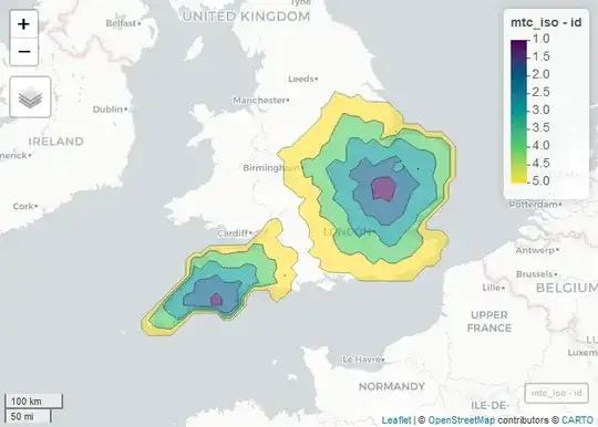
Created on 2023-06-30 with reprex v2.0.2
For map(), something like this would work:
major_trauma_centres %>%
  mutate(iso = map(geometry, \(pnt) unclass(pnt) %>% osrmIsochrone(breaks = seq(0, 150, by = 30))))
This will pass each POINT feature though unclass() first and osrmIsochrone() will receive a vector of coordinates, one of the acceptable formats for loc argument.