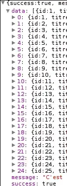
I'm working on creating a web GIS app with OpenLayers. I'm having a difficulty with fetching data from WFS GeoServer.
The data is correctly downloaded, however it is not being drawn in any way. It's just not visible. The WFS server uses polish units - EPSG:2180, so I reprojected it at the beginning. WMS downloaded the exact same way works fine.
<!DOCTYPE html>
<html lang="pl">
<head>
    <meta charset="UTF-8">
    <meta http-equiv="X-UA-Compatible" content="IE=edge">
    <meta name="viewport" content="width=device-width, initial-scale=1.0">
    <title>GEO</title>
    <script src="http://cdnjs.cloudflare.com/ajax/libs/proj4js/2.6.2/proj4.js"></script>
    <script src="http://epsg.io/2180.js"></script>
    <script src="./ol.js"></script>
    <link rel="stylesheet" href="./ol.min.css">
</head>
<body>
    <div id="map" class="map" style="width: 800px; height: 800px;"></div>

    <script>
        /**
         * PROJ
        */
        proj4.defs("EPSG:2180","+proj=tmerc +lat_0=0 +lon_0=19 +k=0.9993 +x_0=500000 +y_0=-5300000 +ellps=GRS80 +towgs84=0,0,0,0,0,0,0 +units=m +no_defs +type=crs");
        ol.proj.proj4.register(proj4);
        ol.proj.get("EPSG:2180").setExtent([0, 0, 1000000, 1000000]);

        /**
         * Place
        */
        let miejsce4326 = [18.05165,53.23004]
        const miejsce = ol.proj.transform(miejsce4326, 'EPSG:4326', 'EPSG:2180');


        /**
         * WFS
         */
        let compURL = 'https://corsproxy.io/?https://mapy.geoportal.gov.pl/wss/service/PZGIK/mapy/WFS/SiatkiPodzialuArkuszowego?service=WFS&Request=GetFeature&version=1.1.0&srsname=EPSG:2180&typename=ms:Ark_50k_42&outputFormat=GML3'
        const WFSvectorSource = new ol.source.Vector({
            format: new ol.format.GML3(),
            url: function(extent) {
                // console.log(compURL+'&bbox='+extent.join(','))
                return compURL+'&bbox='+extent.join(',');
            },

            strategy: ol.loadingstrategy.bbox,
            //draw geoms
            style: new ol.style.Style({
                stroke: new ol.style.Stroke({
                    color: '#ffcc33',
                    width: 2
                }),
                fill: new ol.style.Fill({
                    color: 'rgba(255, 255, 255, 0.2)'
                })
            }),
            projection: 'EPSG:2180',
            visible: true,
            opacity: 1,
            zIndex: 100
        });
        const WFSvectorLayer = new ol.layer.Vector({
            source: WFSvectorSource,
            projection: 'EPSG:2180'
        });

        /**
         * MAPA init
         */
        var map = new ol.Map({
        layers: [
          new ol.layer.Tile({
            source: new ol.source.OSM(),
            projection: 'EPSG:2180'
          }),
            WFSvectorLayer
        ],
        target: 'map',
        view: new ol.View({
          projection: 'EPSG:2180',
          center: miejsce,
          zoom: 12
        })
      });
    </script>
</body>
</html>
I tried reading the documentation, watching tutorials etc. None helped, because this isn't GeoJSON. This server only gives GML. Changing style parameter of vector object doesn't do absolutely anything, same with adding extra parameters (like "projection" to vectorsource object). I expect it drawing geometries and polygons downloaded from WFS on the OpenStreetMap that works as background.
