I'm writing code in grass and i need to calculate this two variables:
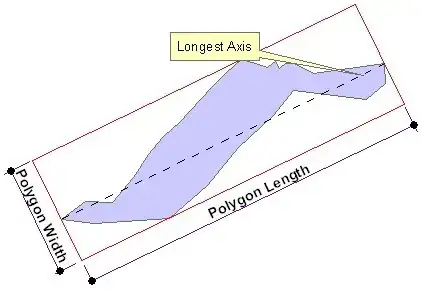
- the length of the longest axis in the units of the Spatial Reference of the input feature class.
- the length of shortest side of the bounding rectangle aligned with the longest axis in the units of the Spatial Reference of the input feature class.
Like the example
I have lots of shape-files and i need that characteristics:
I try with this code in grass
v.in.ogr = ...
v.to.db map=* option=length
but in that case perimeter and length are exactly the same.
I except the output like the figure, two numbers for each shape.