3

I am looking for logic to show various location markers based on area visible through camera view of a device on android. Something similar to attached image. I know following things

  1. Get location
  2. I have all locations to be marked
  3. I know how to create an overlay on camera view
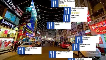
enter image description here

skydroid
  • 733
  • 6
  • 16
vishal dharankar
  • 7,536
  • 7
  • 57
  • 93

5 Answers5

3

You can check my tutorial: https://www.netguru.co/blog/augmented-reality-mobile-android I've described step by step what you need to do to achieve similar outcome but very simplified. If you have any questions I'm ready to help.

Krzysztof Jackowski
  • 170
  • 1
  • 3
  • 10
  • Hi @Krzysztof I have follow your tutorial and able to show some marker on camera view. But some of my marker are getting stuck on the screen and not moving when the camera moves. Also they get duplicate and the duplicated one move properly can you help me what is going on. – jawad bin zafar Jun 17 '19 at 11:33
  • Here is the link to my video https://drive.google.com/file/d/1otQ_mG8orFkPcwwf-fPBwTzVMU0jKIOw/view?usp=sharing – jawad bin zafar Jun 17 '19 at 11:42
1

Each location need to have it own REAL position. For example you need a database of GPS location of each point. Than you analyze frames from your camera. In each analyzed frame you're checking the azimuth on which you are currently looking. Let say you`re looking straight north, azimuth 0 degrees. If we assume that your camera has 90 degree field of view (FOV) than you know that your FOV is from <45, 0) to <0, 315> (in terms of azimuths) Now you need to check which of your points are on such azimuth and if one of them is you just display them

Fixus
  • 4,631
  • 10
  • 38
  • 67
0

Augmented reality is helpful for your problem.

UJWAL GHONGADE
  • 109
  • 1
  • 9
0

After searching a lot found following things An SDK which is open https://artoolkit.org/documentation/doku.php?id=1_Getting_Started:about_installing

and these examples https://github.com/tvbarthel/ChaseWhisplyProject https://code.tutsplus.com/tutorials/android-sdk-augmented-reality-location-distance--mobile-8004

Hope this helps someone else as well.

vishal dharankar
  • 7,536
  • 7
  • 57
  • 93
0

Check this framework https://www.layar.com/. Theres 2 ways to plot your images on view. The first one is, through GPS pre-marked; another one is through image recognition (you can use a simple QRcode cards, I guess it's the most simple. But if your motivated to create a awesome solution, do a grateful solution).

Regards.

Franklin Hirata
  • 290
  • 2
  • 12